Reimagining our Relationship with California’s Water


Water has always been a powerful force in California. It has sculpted our state’s topography and ecology and continues to shape the nuanced realities of life for millions of Californians facing pressured headlines describing recent prolonged droughts and soaring temperatures. Any Californian can tell you that our water is a highly contested and valuable resource, but those from wetter regions may ask, “What’s the fuss about? Maybe there isn’t a lot of water, but shouldn’t that make it easier to manage?”
If only it were quite that simple! During the last ice age, a period known as the Pleistocene that ended about 10,000 years ago, California’s climate was far wetter and cooler than it is today due to the presence of massive ice sheets that covered much of North America and California’s famous Sierra Nevada mountains. These ice sheets were cold enough and thick enough to change continental weather patterns and they forced the powerful jet stream to angle 30 degrees southward, delivering California winter precipitation similar to that of current-day Washington!
Back in those days the canyons and valleys below snow line were filled with water, creating lakes and wetlands that stretched from modern day Bakersfield in the south, to Red Bluff in the north, covering 400 miles of what is now Central Valley prairie, cropland and orchards. These natural and dynamic systems of lakes and rivers have been heavily modified over the past 200 years to support development throughout the state but while water has become increasingly scarce it remains crucial for supporting the ecological integrity of remaining ecosystems and the resiliency of human communities.
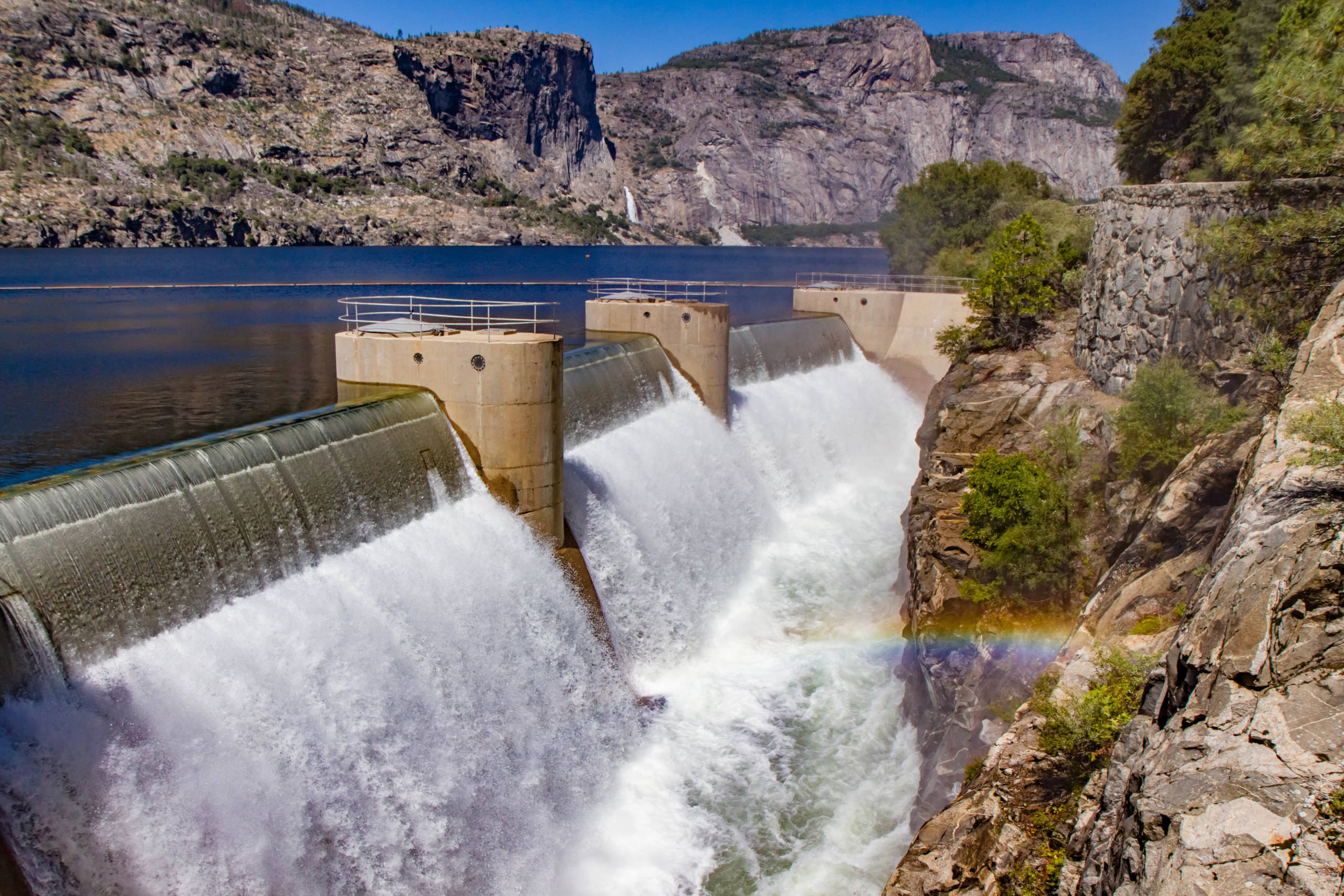
At the turn of the 19th century demand for water increased greatly as the pace and scale of agriculture, mining, and urbanization grew rapidly. The State was in desperate need of a water transportation solution and began developing dams, reservoirs, levees, and canals to move water where it was needed to best sustain agricultural and community thirst. It is difficult to travel anywhere in the state without coming across a vessel either storing or transporting water. The state has over 1300 reservoirs which alongside California’s complex system of canals and pipelines not only work to deliver clean water to residences, businesses, and farms but several of the largest dams also double as power plants for producing hydroelectricity.
One system for storing and moving water throughout California is known as the State Water Project – a network of dams, canals, and pipelines stretching more than 700 miles, supplying water to over 27 million citizens, and claiming several notable superlatives. At the head of this system is Butte County’s Lake Oroville. At 770 feet tall the Oroville Dam is the tallest dam in the United States and impounds a potential 3.5 million acre-feet of water, the equivalent of 2,280,960 Olympic sized swimming pools! Despite this massive capacity, the functionality of Oroville Dam is threatened by the health of its upstream watershed and its structural integrity.
Recent studies of atmospheric patterns and climatologic trends suggest that the pattern of California’s precipitation is sharpening. This means that in future years the region will likely receive equivalent volumes of water as it has in past years, but it will receive this water over a shorter period of time and in high volume spurts, rather than consistent drizzles. This change is analogous to changing the pressure on a backyard hose from “mist” to “jet” and taking aim at a dry patch of dirt, but in this case that dry patch of dirt is California’s most endangered watershed – the upper Feather River.
Quiet rural communities in Butte, Plumas, and Lassen Counties have recently become infamous due to the 2018 Camp Fire, the 2020 North Complex Fire and the 2021 Dixie and Beckwourth Fires which burned a combined 1.5 million acres of forest spanning the Feather River watershed. When rain events hit hard in these fire-scarred forests the results can be devastating as millions of tons of sediment and topsoil rush downstream at a breakneck pace. Without organic material in the soil to attenuate and slow the force of flood waters hill sides and river banks can rapidly erode and critical water management infrastructure such as dams and culverts can sustain severe damage, even those as mighty as Oroville Dam which nearly had its overflow spillway destroyed by intense flooding in 2017. The risk of dam failure put the city and valley below on high alert and continues to remind us all that our greatest hope for future water management may also be our weakest link.
If the State Water Project were to lose functionality California would be in a pinch for additional water sources. Nearly 75% of the state’s water supply accumulates in the watersheds north of Sacramento with the other 25% supplemented from other watersheds and states, including the Colorado River. California has a claim to 60% of the lower Colorado River allotment, a volume of about 4.4-million-acre-feet, but the Colorado River watershed is also facing challenges like wildfire and drought and California has been directed by the U.S. Bureau of Reclamation (the federal agency responsible for the management of many federally owned damns and waterways) to reduce its take from the Colorado River to help preserve reservoir levels and the functionality of the Glen Canyon Dam in Arizona.
While the individual actions of regular citizens can help curb behaviors that waste water, the state of California is advocating for systemic change to address its shortages in water supply, quality, and resiliency. By engaging various state and federal agencies and scores of local partners throughout California’s many watersheds policy makers, foresters, hydrologists, and ecological restoration practitioners are hopeful that the state’s forest, woodland, and chaparral ecosystems can be collaboratively and proactively managed to support community safety, economic prosperity, and ecosystem health.
At Camp California we don’t have to look far or hard for inspiring work in conservation. The Placer County Water Agency suffered significant financial losses following the 2014 King Fire in the American River Watershed due to equipment maintenance and lost power production. To improve their management paradigm and reduce future economic impacts the PCWA has recently partnered with the Sierra Nevada Conservancy (a state funded convener and grantor for restoration initiatives in the Sierra Nevada region), The Nature Conservancy, the Tahoe National Forest, Placer County, the American River Conservancy, and UC Merced to plan and implement the French Meadows Partnership. Outcomes from the Partnership will include ecologically-sound fuel-reduction treatment across a 28,000-acre focal landscape in the central Sierra foothills to reduce wildfire risk and severity and improve water quality and watershed resiliency to natural disturbances like fire, making the American River a safer and more beautiful place to live and recreate.
Collaboration and restoration are sorely needed as water supplies become more vulnerable and less reliable and our fire season becomes longer and more intense. Recent incidents like the 2022 Mosquito Fire demonstrate that the issues of forest, fire, and water management will continue to be critical topics in California even as collaborative management paradigms become more widely adopted and utilized. You can be a part of the solution by addressing water waste in your home and on your property by fixing leaky pipes and faucets or replacing old appliances and encouraging friends and family who might own forest property to consult a Registered Professional Forester and identify goals and objectives for their land that could make their parcel more resilient to fire and drought. More than ever before, being a Californian means being adaptable but there is hope for the future ahead so long as we can collectively conserve our water and forests for current and future generations.